Create a free profile to get unlimited access to exclusive videos, sweepstakes, and more!
Game of Thrones’ unreal landscapes were actually made into a tectonic map

Whether or not you agree with the ending, Game of Thrones has some pretty striking landscapes, from sprawling mountains to sheer cliffs to snowy expanses. There is only one way these places could have formed — whatever altverse version of Earth the Game of Thrones realm exists on.
GoT-obsessed scientists Youseph Ibrahim, Cian Clinton-Gray, Irene Koutsoumbis, and Sabin Zahirovic recently decided to merge fandom and fact when they reconstructed the continents of Westeros and Essos to reflect their plate tectonics. You usually hear about tectonic plates in the news when an earthquake happens. They’re pieces of the crust and upper mantle that drag continents with them when they move. While they still can’t explain the fantasy world’s bizarre seasons, they can at least tell us how places like Dragonstone came to be so majestic.
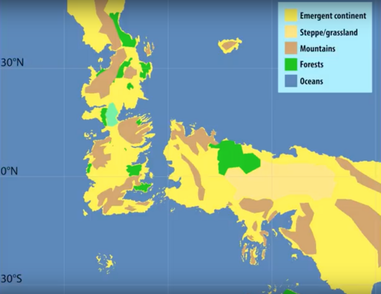
Even in the GoT universe, geological effects can shake up the sociopolitical climate (epic battles, anyone?). The scientists also took into account how the varying topography of places like the Dothraki steppe and the frozen volcanoes beyond the Wall shaped such drastically different societies. Any fictional evidence of volcanism and mountain formation, which usually mean tectonic plates converged at some point, helped build a digital version of the two continents. Speaking of volcanoes, where do you think they get Dragonglass and Valyrian steel?
Dragonglass is GoT’s answer to obsidian, which may look all magical and mystical but is actually lava that cools and hardens especially fast.
Figuring out how the imaginary landscapes formed started with working backward from the phenomenon of seafloor spreading, which occurs when Earth’s violent innards rip continents on the surface apart. Assuming Westeros and Essos split about 25 million years ago when the Narrow Sea first gushed between them, the team mapped this very much like the breaking of Africa along the East African Rift Valley.
Going further back in time proved to be a challenge because of geological evidence disappearing. Erosion, subduction, and mountains forming from continents smashing into one another are to blame. Erosion is the gradual wearing away of surface material, and subduction happens when the edge of one tectonic plate slides beneath another. Up until 45 million years ago, India was separated from the conjoined continents of Europe and Asia by Tethys, a real Narrow Sea. Its fusion with the Eurasian continent is the reason the Tibetan Plateau and the Himalayas exist.
Think about all those unreal snow-capped mountains on the show and how they must have come into being. There must have been almost as much violence beneath the surface as there eventually would be when Winterfell took its last gasp before charging at the army of the undead. Ice zombies aside, those mountains weren’t conjured by sorcery.
Now prepare to be almost as amazed as you were at your first glimpse of a dragon when you see how Westeros and Essos supposedly came into being.
(via The Conversation)


