Create a free profile to get unlimited access to exclusive videos, sweepstakes, and more!
Is that Helm's Deep, or did drones finally find the ancient lost city of Natounia?
All we needed were some eyes in the sky.

History is a black box, illuminated only by our faulty recollections and incomplete historical records. Things are so easily lost to time, from individuals and events to entire cities. What little information we do have about our own past sometimes reveals, or at least suggests, the existence of lost civilizations. From Atlantis to El Dorado, explorers have spent generations hunting for cities which might never have existed. Even those which might have existed have, over the centuries, been swallowed up by the world and hidden from view.
Natounia was one such city. Known only from a handful of coins, archaeologists were fairly confident it had been a real place — ancient peoples weren’t in the habit of minting money just for the fun of it — but any hint of its location was shrouded. Now, thanks to advancements in mapping technologies, it might have been found at the mountain fortress of Rabana-Merquly.
Michael Brown from the Institute of Prehistory, Protohistory and Near-Eastern Archaeology of Heidelberg University, along with Iraqi colleagues Kamal Rasheed Raheem and Hashim Hama Abdullah, uncovered the ancient city in the Zagros mountains with the help of drone mapping. Their findings were published in the journal Antiquity.
Parts of the city were uncovered in 2009, but the rugged terrain and dense coverage prevented researchers from seeing the full complexity of the settlement. They had originally believed it to be an isolated building with a few smaller out-buildings nearby.
“It’s pretty rugged terrain and difficult hiking. You have to hike up a little bit, fly around with the drone and map a section, but then you’re out of range. So, you have to hike up again and map a little more, over and over,” Brown told SYFY WIRE.
All the disparate mapping images were then gathered and processed, building a complete map of the area. Ultimately, researchers found a vast complex surrounded by a perimeter wall running roughly four kilometers.
“The perimeter wall is a mixture of cliff, towers, and walls. The comparison I always use is Helm’s Deep from Lord of the Rings. It’s pretty much that, but real. It’s a naturally defensible mountain, which I’m sure is why they chose it. Then, inside the wall are all sorts of diversified structures,” Brown said.
While the settlement would have served as a fortress, easily defensible from any adversaries, Brown and colleagues believe it had other more peaceful functions as well. Inside the walls are a number of buildings which indicate it might also have been a common point of trade and maybe even a pilgrimage destination. It’s possible, though unconfirmed, that the city also houses a unique alter to the goddess Anahita. During one of the team’s expeditions, the site was hit with heavy rains and a temporary waterfall formed in the middle of the complex. Researchers think that might have been by design.
“This is quite speculative, but in Zoroastrian religious practices, which would have been predominant in that area 2,000 years ago, there was a goddess called Anahita who could manifest as a waterfall. There’s not much known and nobody has ever found a sanctuary of Anahita, so we don’t have any comparisons,” Brown said.
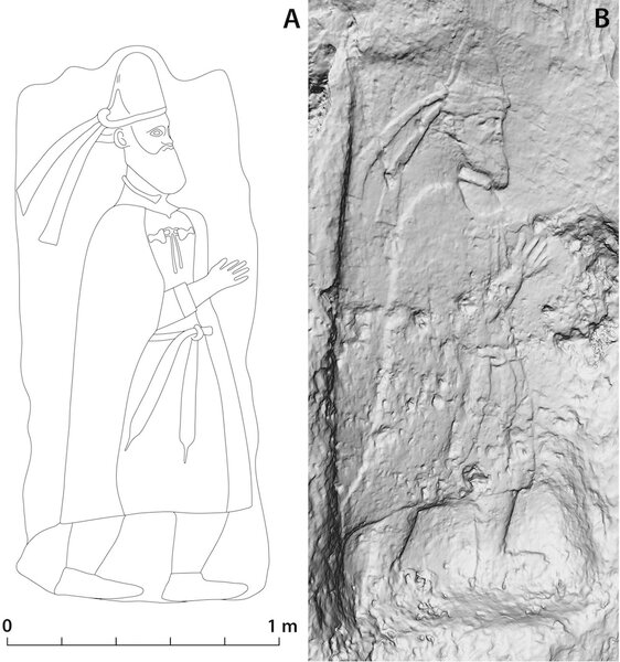
The evidence for Rabana-Merquly being the lost city of Natounia rests on those rare coins and a pair of relief statues at the entrance of the fortress. The coins, of which there are only seven known examples, hail from a city called Natounia on the Kapros. The name on the coins gives archaeologists a hint of where the city should be located. Kapros was the ancient name for the Lower Zab River, so if the city exists it should be found somewhere on the watershed of that river.
There are a number of candidate sites along the Lower Zab, but Brown believes Rabana-Merquly is the best one. It’s certainly the largest, and it’s a royally founded settlement from the right time period. The only wrinkle is that it’s not technically on the Kapros.
“It’s on a tributary of the river, not the main channel. But it’s a very big tributary and whether or not an ancient geographer would have made that distinction is not quite clear,” Brown said.
The relief statues at the fortress entrance provide another compelling clue. The statues are anonymous, but they have a striking resemblance to a statue from Hatra of King Adiabene. That statue has an inscription at the bottom indicating its of a descendant of Natounissar.
“Natounia is obviously a place name derived from this guy’s name. Clearly, we are related to that group of rulers. We’re a good candidate for Natounia, but we can’t prove it unless we find a cache of these coins. I don’t think we will, but it’s a good candidate, I’d probably put money on it,” Brown said.
Future archaeologists might have an easier time of things. It’s simpler to identify a place when there’s a giant billboard announcing your entrance to Milwaukee, but ancient builders weren’t so accommodating. Instead, we’re left with complex and incomplete puzzles to solve. Regardless, the findings are exciting all on their own. A mountain fortress by any other name is still pretty sweet.


