Create a free profile to get unlimited access to exclusive videos, sweepstakes, and more!
Cloudy with a chance of Chinook Arches

Years ago, literally the very week I moved to Colorado, I saw a truly weird thing out my window. It was a meteorological phenomenon (or "cloud thingy," as nebulaphiles call them) that I had never seen before, and it really threw me at first.
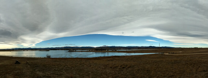
What I saw was a cloudbank that stretched from the east to just before the mountains. There, it stopped in a very nearly straight line that reached north and south as far as I could see. To the west of it was absolutely clear blue sky.
But the really weird thing was it didn't move. I glanced back at it every few minutes for hours and it was virtually the same view every time. It was like a huge spaceship hovering over the landscape from the southern to northern horizon. Here in the plains to the east of the Rockies, the wind almost always blows from the west, and clouds flow eastward. This one … didn't. Like it was painted on the sky.
I emailed a couple of local TV stations and left messages for meteorologists about this, and even contacted atmospheric research groups, but never heard back. I had a suspicion at the time about what I was seeing, but it took a while to confirm. And the name for it came even later … but I've seen it many many times since, including just the other day when I was out and about. My phone camera has a pretty good panorama setting on it, so I can now finally share this weird thing:
Whoooooaaaaaaa.
Mind you, this is a panorama, so the field is distorted; you're seeing it like it's through a fish-eye lens, and the line between cloud and blue sky is far more straight by eye. This pano covers almost 180° around the horizon (by comparison, a normal photo has a field of view of about 75° or so). The center is more-or-less west, and you can see the weird cloud structure I mean: It covers the whole sky above and behind me (to the east), but ends abruptly over the mountains to the west.
Note that this structure is huge: Assuming the line is above the tallest mountains (a guess, I'll admit, but likely given the mechanism I describe below), this line extends several hundred kilometers north/south. If I had been closer then the part of the line nearest me would look higher in the sky than the parts farther north and south, giving it the illusion of being curved, more arch-like.
And that's where the name for this phenomenon comes in. Initially, I couldn't find what it was called despite many attempts, but then in an unrelated search on powerful Colorado winds I got my answer. These winds are called "Chinooks," and I was looking up something on how they form, and then right there on the Wikipedia page a subsection caught my eye: the Chinook Arch. That's it! And I love the irony: The arch is unrelated to the Chinook wind, so my finding the term was a complete accident.
So what causes this weird thing? You need wind moving moist air toward the mountains from the west. When the air hits the westward slope it rises, flowing up the mountain — this is called orographic lift. As it rises it cools, and when it gets high enough the moisture it carries condenses into a cloud. This sometimes happens once the air has cleared past the mountain, in which case it's called a lee wave cloud*. If the wind is steady and stretches far enough north and south, you get cloud formation along that long, long line. When you see that blue sky beyond you're actually looking through that same moist air, but it hasn't risen high enough yet that far west to form water droplets, so it's transparent, and you see clear sky.
And while the line is stable, the cloud is constantly changing. The wind is still blowing east, so the air is always moving, but the line is just where the air gets high and cool enough to form the cloud. It's like a traffic jam that can last for hours, even if any individual car moves in and out of it in a few minutes. So you can look an hour or more later at a Chinook Arch and it can still be there, even if the water droplets making up the cloud itself have changed.
I saw one of these a few years back and took video that shows all this and trust me, you want to spend a minute watching this all the way through to the sunset, because holy wow.
I stood slack-jawed watching that, believe you me. The sculpted flow under the clouds was just beyond glorious (at the link above is more video and more photos, too). Sadly the Chinook Arch I saw recently didn't last until sunset, dissolving in the mid-afternoon. But it'll happen again — and again, and again — here, so I'm hoping to get even better video sometime.
You might think that clouds are the astronomer's nemesis, but under the right circumstances they fall firmly under our purview: beautiful and soul-filling wonders of the sky.
Keep looking up, folks. There are always treasures to behold.
*In the original text I didn't make it clear that this cloud formation is downwind from the mountain, making it sound like it was an orographic cloud instead of a lee wave cloud. I have edited the text to clarify. My thanks to BABloggee RC Gibbons for pointing this out to me.


