Create a free profile to get unlimited access to exclusive videos, sweepstakes, and more!
South Sandwich Island wave cloud interference

I love weird clouds. If you've been following me for any length of time at all this should be obvious; where I am in Colorado affords me to see all sorts of bizarre structures like mammatus, fluctus clouds (seriously, click that), lenticulars, wavy cirrus smoke streamers, and even more familiar clouds like vast cumulonimbus storm clouds are revealed in all their magnificence.
Still, some formations need very special circumstances to come into existence, and happily the Earth Observatory Image of the Day — one of my very favorite sites on the whole ‘net — is only happy to provide images of them. Check this out:
How weird! What's funny to me is that although I have never seen this exact phenomenon before, my experience reading about clouds a lot let me know right away what I was seeing: Leeward wave clouds interfering with each other.
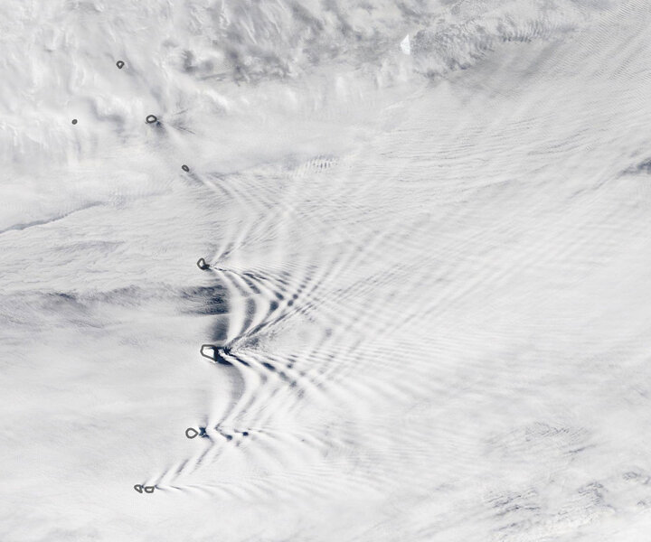
OK, one step at a time. The outlines you see are the South Sandwich Islands, way down in the South Atlantic not too far north of Antarctica. The islands are volcanic, with some peaks around 1,000 meters above sea level.
Winds blowing to the east (to the right in the image) flow around the islands, creating wakes like a boat moving through water. The air is pushed up as it flows around, then falls back down, creating wave-shaped ripples downwind.
If conditions are just so, water vapor in the air can condense when it rises high enough, then evaporate again when it falls down, so the wave ripples become visible; white clouds at the peaks and darker clear air at the troughs.
That in itself would be cool enough, but because the islands are close enough together (roughly 60 km apart from one to the next) the waves off each islands meet up with the waves from the next, creating interference patterns: Where a crest meets a crest you get an extra tall crest, where a trough meets a trough you get an extra deep trough, and where trough meets crest they cancel out. This creates a lovely crisscross pattern downwind as well.
As the EOID site notes, there are likely waves coming off the northernmost islands as well, but a layer of higher clouds blocks them from view. This image was taken by NASA's Terra satellite, designed to monitor Earth's air, snow, ice, and ocean, to help us better understand climate change and the effects on all these systems (though to be fair it does sometimes catch big meteor explosions, too, and volcanic eruptions as well). Sometimes, though, it winds up returning just breathtaking images of our planet.
And I'm thrilled that things like this exist at all! Here is a phenomenon that I certainly haven't seen before, and likely never could in person (from the ground or from space), but we can see it, we can explain it, we can understand it. I love that there is still so much of our Earth to see and explore, so much to wonder at, and so much of its previously unseen beauty to soak in.


