Create a free profile to get unlimited access to exclusive videos, sweepstakes, and more!
Spinning Up a Storm

So, I hear thereâs snow on the East Coast.
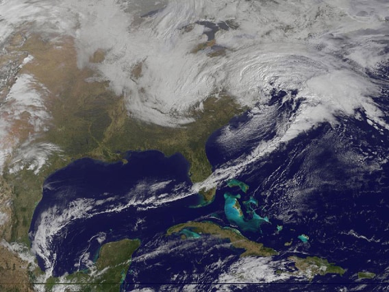
That image, taken earlier today by the NOAA/NASA satellite GOES-13, shows the winter storm currently dumping snow on the United States coast. You can see warmer moist air to the east and south feeding right into and helping power it.
Low-pressure systems are fascinating to me. Because the air pressure is lower in the middle, they draw air in, toward them, like a vacuum. But thereâs a twistâ¦literally.
The Earth is a spinning sphere. At the Equator, it rotates at about 1700 kilometers per hour (1000 miles per hour), but at the pole that speed (called the linear or translational velocity) is zero. So air nearer the equator is moving to the east much faster than air at more northerly latitudes.
When a low-pressure system draws in air from the south, that air is moving eastward faster than the air at the center of the system. As it is drawn north, it curves to the east. The opposite is true for air coming down from the north; itâs moving eastward more slowly, so it curves to the west relative to air in the system. This sets up a counter-clockwise rotation, and itâs characteristic of low-pressure systems.
Sound familiar? We call this the Coriolis effect. It has the opposite sign in the southern hemisphereâa low-pressure system rotates clockwise south of the equator. And, I must note, this has no noticeable effect whatsoever on toilets, bathtubs, or water basins. You need motion over large scales, many kilometers at least, for this effect to take hold.
Just to be thorough, a high-pressure system spins the other way (clockwise in the northern hemisphere) because now air is flowing outward from the center, not inwards. Everything I described above is reversed.
In the storm hammering the U.S. right now you can see this rotation. The clouds near the center have taken on a comma shape. Air drawn in from the south is deflected east (to the right) as it moves north, and air drawn from the north is deflected west (to the left), and the system starts to rotate. When a storm like this moves to the coast, the air coming from the south moves over the Atlantic where it can pick up moisture before looping back over and around the storm. If the water is warmâand itâs been abnormally warm recently thanks to global warmingâa storm can really pick up steam (so to speak) and dump a lot of precipitation. Thatâs what weâre seeing now, though happily not to the extent we did with Sandy or Februaryâs nor-easter.
If youâre living under this storm, then stay warm! And if it helps any, please know what youâre suffering through is actually quite beautiful when seen from above. Even if that is cold comfort.


