Create a free profile to get unlimited access to exclusive videos, sweepstakes, and more!
Space Radar Reveals Parts of NYC Are Sinking, Others Are Rising
Can you feel the ground moving beneath you?

The classic post-apocalyptic adventure Waterworld takes place in a future wherein all of the world’s ice caps have melted, raising the global sea level and swallowing all of civilization. Fortunately for us in the real world, it wouldn’t be quite that bad. Scientists estimate that even if all of the world’s ice were to melt, global sea level would only raise about 70 meters.
That’s good news for the future of humanity, but our activities are causing our cities to slowly sink, according to new research from scientists at Rutgers University and NASA’s Jet Propulsion Laboratory. Researchers used space-based radar measurements from the ESA’s Sentinel-1 satellites to measure changes in altitude across New York City and found the city is sinking 1.6 millimeters (0.06 inches) every year.
NYC Is Sinking Thanks to Glacial Rebound
While things won’t get quite as bad as Waterworld suggested, many coastal cities are investing in safeguards to protect against the looming consequences of climate change. Based on these recent measurements, New York City residents should concern themselves with rising waters, but they also need to think about a sinking city.
While the metropolitan area is sinking at an average rate of 1.6 millimeters per year, some areas are sinking significantly faster. Using two or more space-based radar measurements of the same area, scientists were able to create a highly detailed map of the city, highlighting the rate of upward or downward movement — also known as uplift and subsidence — between 2016 and 2023.
RELATED: Sunken City From Over 2,000 Years Ago is Like the Egyptian Version of Atlantis
The factors related to land movement are complex, but much of the subsidence in New York City is concentrated in areas where the land was previously modified. Roughly 24,000 years ago, a massive glacier cut through New England, compressing the ground beneath it and lifting nearby land upward. Over the last several thousand years, the land has been readjusting back to something like its prior position. New York City is built atop land that was lifted by the glacier and it’s slowly settling.
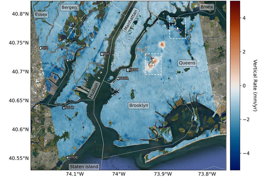
That probably explains a significant portion of the city’s subsidence, but not all of it. The map that scientists created is so detailed they were able to identify how much specific neighborhoods and landmarks are sinking. “We’ve produced such a detailed map of vertical land motion in the New York City area that there are features popping out that haven’t been noticed before,” said lead author Brett Buzzanga, in a statement.
Some Areas of New York Are Sinking Faster from Human Activity
Arthur Ashe Stadium, for instance, is sinking at a rate of 4.6 millimeters (0.16 inches per year) three times the average rate of nearby areas. That’s because the stadium is built on top of an old landfill, which is more susceptible to compression than more mature sediments. Already, the stadium had to have its roof replaced in an effort to reduce the overall weight and minimize sinking.
RELATED: Some Three Decades After Waterworld the Movie, Universal Studios' Live Stage Show Remains a Must-See
Strangely, some parts of the city are actually rising. Part of East Williamsburg, Brooklyn is rising at the same average rate as the rest of the city is falling. Not to be outdone, Woodside, Queens rose more than a quarter of an inch every year between 2016 and 2019. At present, it isn’t clear what’s driving those atypical upward ground movements, but the uprise in Woodside has already stopped, suggesting it may be a temporary phenomenon in most places.
Regardless of the causes, understanding how ground level shifts over time has implications for flood mapping and management, something which will be increasingly important as climate change raises the threat of floods. It could also inform city maintenance plans as susceptible buildings and neighborhoods are identified.
Given enough time, New York City’s ground level studios and high rise penthouse apartments could change places. But at rates of just a few millimeters a year, it’s going to take a while.
In the meantime, revisit a world made of sunken cities in Waterworld, available from Universal Pictures.


