Create a free profile to get unlimited access to exclusive videos, sweepstakes, and more!
A Rare Monster Seen from Space
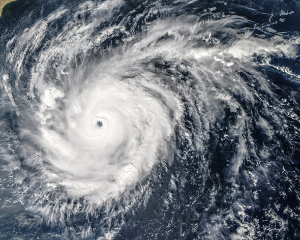
Yemen and Oman are bracing themselves for the landfall of Cyclone Chapala, a huge and powerful hurricane-force storm on the Arabian Sea. This is an extremely rare event, and forecasters are predicting it will dump several years worth of rain onto the normally desert-dry area in just a few days.
My Slate colleague Eric Holthaus has an excellent overview of this event. The good folks at Weather Underground are also keeping tabs on it.
So are NASA’s and NOAA’s eyes in space. The cyclone has been observed using several critical Earth-observing satellites, including Aqua, Terra, Suomi-NPP, and even astronauts on the International Space Station. The images returned from space reveal this terrifying storm to be, paradoxically, incredibly beautiful.
The image above, taken using the Aqua satellite, is from Oct. 30, 2015. Chapala has a well-formed eye, and feeder bands (the spiral-arm clouds) extending for well over 1000 km. At the far right you can see the west coast of India, and on the left Oman on the Arabian Peninsula. Aqua collects data on Earth’s water cycle, including ocean evaporation, clouds, rain, snow, and ice on land and sea. It’s an important part of understanding how water and its circulation affect our planet.
This next shot is from Suomi-NPP, a satellite that’s part of a joint venture with NASA, NOAA, and the Department of Defense. Like Aqua, it too monitors Earth’s water, helping us understand how global warming is affecting the Earth. When the image was taken, Chapala was still close to India.
Astronaut Scott Kelly is on the International Space Station for a year-long flight, and captured this astonishingly lovely photo of Chapala (note he misidentified the name in that link), seen at a highly oblique angle on the horizon. I believe the color contrast in the photo has been enhanced a bit, but it still shows the immensity of this storm.
Finally, the Terra satellite took this shot of Chapala on Oct. 28. This captures the first few hours of the development of the eye of the cyclone, clearly seen in the center. The cyclone actually lost power on Oct. 30, probably due to dry air from the region impeding on its feeding circulation. Cyclones like this get their energy from evaporating water, which rises with warm air. When the water recondenses the heat stored in it is released, creating more energy to feed the circulation, which draws in air from around the storm, bringing more water with it. The cycles continues as long as there is warm, moist air above the water.
The Arabian Sea is small, so it’s difficult to produce big storms there. But the waters are experiencing record warmth, and this is what is feeding the monster.
Even as our planet rages, it produces astonishing beauty. But do not be fooled by its glamour. This storm could very well bring record floods and do hundreds of millions of dollars in damage to the area, and, of course, take a toll in human life.
The world is changing, literally right in front of our eyes, and this is what we have sown. Perhaps these views from space can help save lives and property, since they give scientists better insight into the storm as it develops, evolves, and moves. Forewarned is forearmed; the Earth is telling us what it’s doing, and if we want to save ourselves, we need to listen.

