Create a free profile to get unlimited access to exclusive videos, sweepstakes, and more!
A Typhoon and a Cyclone Are Aiming for Land
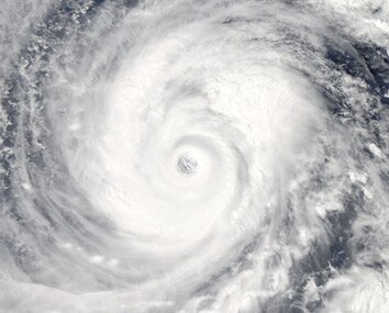
Two tremendous storms* are heading for landfall on the other side of the world from the U.S. Both are phenomenally dangerous … yet both are exquisitely beautiful when seen from space.
That is Supertyphoon Vongfong, which is in the Philippine Sea, and on course to hit southern Japan. It’s a Category 5, with wind speeds measured on Oct. 9 as 145 knots (nearly 270 kph). It may weaken slightly before hitting landfall, which would be nice for the people in its path. On Oct. 7, the NASA TRMM satellite measured rainfall near the eyewall of about 10 cm/hr (4 inches/hr).
That image was taken by NASA’s Aqua satellite, designed to study the water cycle of our planet.
The typhoon was also photographed by astronaut Reid Wiseman from the International Space Station:
That shot of the eye is amazing. Given the perspective (how close the eye is to the limb of the Earth) I’d guess the eye was well over 1,000 kilometers away when he took this picture, perhaps even twice that. He used a wide angle lens, so it’s difficult to be sure. Either way, this shows just how huge this typhoon is.
The other storm is Cyclone Hudhud, currently predicted to make landfall in India on Saturday or Sunday local time:
That Aqua image was taken on Oct. 9. Although not as well organized as Vongfong, it’s still a Category 1 storm (predicted to grow to Category 4) and is expected to hit a heavily populated region of India.** After a devastating storm landfall in 1999, India is better prepared to deal with this type of event. You can read more about it in my colleague Eric Holthaus’ article on Slate.
I’ve been through enough big hurricanes to know how terrifying they can be, and how much devastation they can deal out. It’s jarring and disturbing that the bringers of such terror can be so pleasing to the eye from space.
Distance can bring perspective, but in this case both the beauty and the dread are things worth bearing in mind.
It’s also worth remembering that it’s satellite images (along with data from others like TRMM) that allow scientists to make better predictions of where these monster storms will hit, and how much damage they can bring. The people working on this are saving lives, and billions of dollars. That’s what science can do.
*The general term for storms like these changes depending on location. The NOAA has the best definition I’ve seen:
Hurricanes, cyclones, and typhoons are all the same weather phenomenon; we just use different names for these storms in different places. In the Atlantic and Northeast Pacific, the term “hurricane” is used. The same type of disturbance in the Northwest Pacific is called a “typhoon” and “cyclones” occur in the South Pacific and Indian Ocean.
Vongfong is in the Northwest Pacific, so it’s a typhoon, while Hudhud is in the Bay of Bengal/Indian Ocean, so it’s a cyclone.
**Correction, Oct. 10, 2014, at 16:00 UTC: This post originally misstated that Hudhud is Category 4, but it's predicted to grow to that size.

