Create a free profile to get unlimited access to exclusive videos, sweepstakes, and more!
Hurricane Isaac menaces the Gulf coast
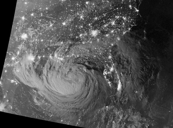
Hurricane Isaac is hitting the Gulf coast of the US right now, battering the area with 120 kph winds. Just after local midnight on August 28, the Suomi NPP Earth-observing satellite took this eerie and beautiful picture of Isaac when it was still a growing tropical storm:
[Click to encoriolisenate; bigger versions are available on Flickr.]
This picture
is a combination of several images taken in different filters, including is in the visible light and infrared, and uses light intensifiers to make faint things viewable [Note: this is actually one image, not a composition of several filtered images. Thanks to Robert Simmon for the correction!]. The waxing gibbous (just past half-full) Moon didn't set until after 2:00 a.m. local time, so it's possible the cloud illumination here was coming from that. And of course you can see the city lights, including New Orleans already under the outer bands of the storm.NASA's Earth Observatory just posted another, more recent picture in visible light from the Terra satellite, too.
Pictures of hurricanes from space are amazing. As always, there's a fascinating dichotomy to pictures like this, a simultaneous ethereal beauty and repellent violence. Hurricanes are magnificent, and terrifying.
I hope everyone in the area stays safe. I've been through a few hurricanes, and they're not fun at all.
Image credit: NASA Earth Observatory
Related Posts:
- Mosaic of home
- Giovanna slides into Madagascar
- The pressure of living on a spinning planet
- Hurricane Irene from start to finish
