Create a free profile to get unlimited access to exclusive videos, sweepstakes, and more!
NASA's Mars Pathfinder may have landed at the edge of an ancient inland Martian sea

Today, Mars is dry, cold, and has an atmosphere so thin that it makes the top of Mt. Everest feel cozy by comparison.
But billion of years ago, Mars was very different. It had thicker air, was much warmer, and had water on its surface. A lot of water.
How much? A new paper just published indicates that NASA's Mars Pathfinder rover landed between what was once a vast northern ocean and an inland sea to the south. The area around Pathfinder's landing site was once subjected to catastrophic flooding from that sea, with some floods reaching heights of nearly a kilometer and moving at over 500 kilometers per hour!
!!!
Pathfinder landed on Mars in 1997, carrying the first (Sojourner) of what would turn out to be a phenomenally successful series of rovers. The landing was chosen specifically because of the interesting flood-like geology there, as determined from orbital surveys.
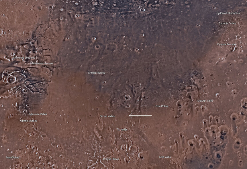
Pathfinder landed in the northern parts of two valleys called Tiu and Ares Valles. A vast plain called Chryse Planitia, over 1,000 km across, lies to the north, and to the south is a region the authors called the Simud Interior Basin. Much of this region is clearly the result of erosion due to something flowing. There has been a lot of uncertainty over whether it was lava or water, but the authors of the new work argue it was water.
In their analysis, water flow would have started to the south and west, flowing north and east. The Simud basin would have trapped this water, ponding and creating an interior sea at that location. Two valleys to the north, Tiu and another called Simud Valles (the basin is named after it) were the only outflow routes for water from the sea. The basin has smooth sedimentary material in it, indicative of stable water. The area of this sea would have been about 430,000 square kilometers, roughly the same size as California, and would have had the same volume as the Caspian Sea here on Earth!
The outflow valleys to the north of the basin show extensive evidence for flooding, including scoured grooves and teardrop-shaped islands. Dating of the region shows that there was periodic flooding as early as 3.8 billion years ago, peaked around 3.4 billion years ago, and then eventually stopped something less than 3 billion years ago.
The authors argue that, had this flooding been due to lava or debris flows, the inland sea would have filled up and been buried. The fact that we see it at all indicates a much less viscous source: water.
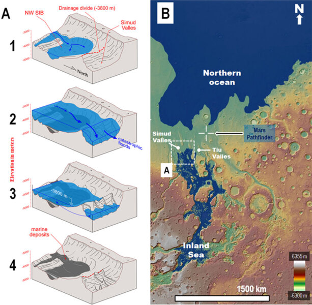
The graphic above shows what they think happened all those eons ago. On the right is the context, showing the region around where Pathfinder landed; red is higher elevation and blue lower.
On the left are cartoons showing how water flowed and ponded. At the top (1) is the inland sea at normal levels, prevented from flowing to the right (northwest) by a large ridge. But huge floods (2) would have overflowed the ridge, inundating Simud Valles. The water recedes (3) leaving behind a flooded area to the northwest. Eventually, after a few thousand years, the seawater water evaporated (4) leaving behind sedimentary marine deposits.
The water that overflowed would have screamed down those valleys to the north, eventually ending up in what is now Chryse Planitia. Given the topography of that area, it would have formed a huge bay of a much larger ocean that would have covered what is now Acidalia Planitia. That ocean would have extended over much of the northern latitudes of Mars!
Planetary scientists have hypothesized for some time that there was a great northern ocean and these observations support that notion. I've been reading about it for years, but somehow this new work makes it seem more alive to me; the complex nature of the geology and water flow fills in the details that make it seem, well, more Earth-like — if you've ever observed the sculpting done by water flowing in a creek or watched an actual flood you can see how complicated it is.
As I've noted before, three billion years ago Mars was more Earth-like (meaning like Earth is now) than Earth was back then. I have to wonder what that Mars, terribly removed in the past from us, was like. Was the sky blue? Did it rain, did hurricanes form over the oceans? Was there life there?
If we ever find out it'll be because we have been so well focused on understanding Mars, on sending different missions with different instruments on board to get as broad a grasp on conditions there as possible. All of this new work was done using laser altimeter data from MOLA on board the Mars Global Surveyor, images from the HiRISE camera on Mars Reconnaissance Orbiter, and observations made by Pathfinder and Sojourner on the ground. The more we study this planet, from space and form the ground, the more we'll understand it and, I hope, in contrast our own.


