Create a free profile to get unlimited access to exclusive videos, sweepstakes, and more!
Pyrocumulus cloud
As I write this, the High Park fire is the second largest wildfire in Colorado history, currently at 75,000 acres (over 300 square kilometers, or 115 square miles). It's been burning more than a week, and fighting it has been difficult due to dry conditions, wind, and oppressive heat in the area.
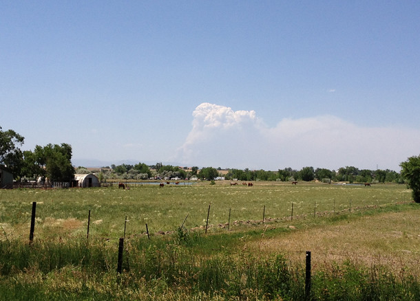
I can see the fire from Boulder, but yesterday I got a really good, if terrifying, view of it driving home from the airport. There was nothing but farmland and one low range of hills between me and it. I stopped and took some pictures with my phone:
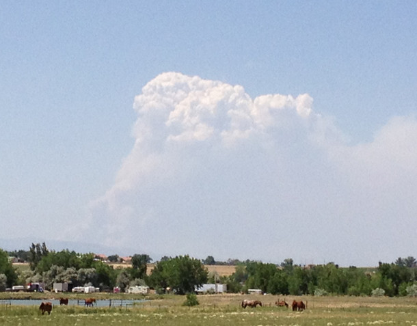
I was about 55 km (35 miles) south of the fire when I took this. Note how the plume is whitish and looks like a storm cloud. I discovered there's a word for this: pyrocumulus; "pyro" means fire, and "cumulus" is Latin for heap or piled up. Cumulus clouds are the ones that are the big puffy cauliflower-shaped ones. The puffiness is from convection, which is when hot air rises and cold air sinks. Usually, warmer moisture-laden air punches upward into the cooler air above it. The water condenses, and all the little convection cells give the cloud that lumpy appearance.
In this case, the fire is hot, and the air is thick with smoke as well as water from the efforts to put it out [UPDATE: As Dan D points out in the comments below, water from the vegetation contributes to this as well]. It rises rapidly, forming the pyrocumulus cloud. They're usually grey, but I suspect the towering cloud I saw is white due to the water vapor. The smoke plume from the fire is blowing to the east (right), and stretches for a long, long way:
It actually extends well off to the right, outside the frame of this picture. The smoke plume is noticeably reddish to the eye. I was cycling up that way last week, just the day after the fire started, and the smoke plume was reddish-brown with a blue tinge to it around the upper edges. I suspect this is due to scattering. Incoming light of all colors from the Sun hits the cloud. Longer wavelength red light penetrates deeply into the cloud, but blue light only gets a short way in before scattering off the smoke and ash particles. Think of them like blue photon ricochets, hitting the cloud and bouncing off in all directions.
The upshot is that we see blue light coming from the edges of the cloud where it gets scattered, but the lower part of the cloud looks redder because of the intrinsic color of the smoke, and also because only the red light form the Sun gets through it (similar to why sunsets look red). The overall effect is eerie, and unpleasant.
Which fits. This fire is pretty bad, and it's joined by many other fires in Utah and New Mexico, not to mention in other countries like Russia. I'll note that it's difficult to pin this down to global warming, but as the planet does warm, different weather patterns will make some places wetter, others drier. One commonly predicted outcome is more and bigger fires, and it does seem we're approaching or breaking a lot of records lately.
Related Posts:
- Boulder fire from space
- Sunset on an alien world
- ⦠I meant, Stardust "@" Home (more about this blue/red light effect from scattering)
- The twice reflected Moon light
