Create a free profile to get unlimited access to exclusive videos, sweepstakes, and more!
The Half Earth Catalog
Oh, that planet of ours.
On Feb. 11, 2015, a SpaceX Falcon 9 rocket launched with the Deep Space Climate Observatory, or DSCOVR, on board. The sat was slowly eased into an orbit 1.5 million kilometers (just under a million miles) away from Earth and toward the Sun, into a gravitational soft spot called the L1 point. There, the gravity of the Earth and Sun balance (if you account for the Earth’s centrifugal force as it moves around the Sun too).
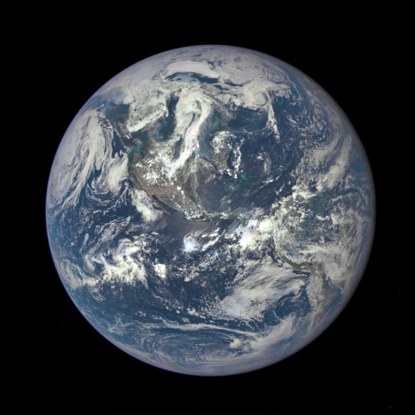
Safely ensconced at this height, DSCOVR looks earthward, taking images of our planet using 10 different color channels, allowing scientists to monitor climate change among other important gauges of Earth. From that distance, very nearly 50 percent of the planet can be seen, and the camera was built to fit all that magnificence into one straight shot. As the Earth rotates, over the course of a day or so the entire surface will be seen and photographed. Starting in September, the images will be available to the public in just a day or so after they’re acquired.
Given that the camera has a 4 megapixel detector, they should be routinely gorgeous … as the image above testifies. That is a red-green-blue picture, showing pretty much what our eyes see. Centered on Central America, you can see the continents, cloud patterns, and the aqua waters around the Caribbean. The milkiness around the edge is probably due to atmospheric effects—haze and other stuff in the air mucking up the view. When you look toward the Earth’s limb this way you’re looking through more air, so the effect is more pronounced.
I’ll be very interested in seeing the infrared images, too, which will show how well the Earth reflects incoming sunlight. While DSCOVR has many mission goals, one is to monitor indicators of global warming, and looking in the IR is a good way to keep track. That is, after all, the root of the problem: Sunlight warms the Earth, and the Earth radiates away that heat as infrared light. Carbon dioxide in the air absorbs a small fraction of that heat, so the Earth doesn’t dump it as efficiently, and the planet warms up.
The satellite will also monitor solar weather—subatomic particles streaming from the Sun. But of all the things it does, I suspect its constant streaming of pictures of our planet to the public may wind up being its long-remembered legacy. There is something transformative about seeing Earth from space, something that touches a part of us deep in our brains.
That’s home. And, for now, it’s the only one we have. Keeping a close eye on it is a smart thing to do.


