Create a free profile to get unlimited access to exclusive videos, sweepstakes, and more!
UPDATE: California Rim Fire from Space
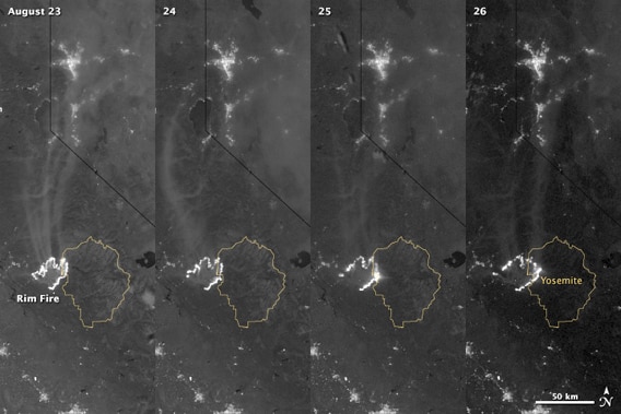
Just a quick update to the huge Rim Fire burning in California: After I wrote the post that went up earlier today, NASA released new images of the fire taken from space. They are from the Suomi-NPP Earth-observing satellite, taken with a camera that sees in both visible and infrared light:
The four frames show the same area over the course of four days, from Aug. 23 to Aug. 26. The thin yellow outline is Yosemite National Park, and the fire is the thick jagged white line, detected via its own light (the angled black line above is the California/Nevada border).
You can see the fireâs growth over time, spreading into Yosemite on the 25th and taking firm hold there the next day. It appears to be weakening a bit to the northeast, but spreading to the southeast. Note the scale bar at the bottom right; itâs equal to 50 kilometers (30 miles), showing you just how big this fire is.
Suomi-NPP was designed specifically to observe the Earthâs land, ocean, and atmosphere, looking for natural and human-driven changes. The highly-sensitive camera used here can look at faint phenomena illuminated by the Moon, or by man-made lights. Fires show up very well this way; last year in August it took eerie pictures of the remote Russian wildfires that were burning out of control.
For up-to-date information on the fire, I suggest InciWeb, which has maps, locations, size, and status of the fires currently burning across the United States.
Correction (Sep. 8, 2013): I originally wrote the fire was detected by its own heat, but Suomi-NPP doesn't see that far in the infrared; it can detect light just outside normal human vision. My thanks to Robert Simmon for pointing this out.

