Create a free profile to get unlimited access to exclusive videos, sweepstakes, and more!
OSIRIS-REx snapped a pic of the Earth as it passed by

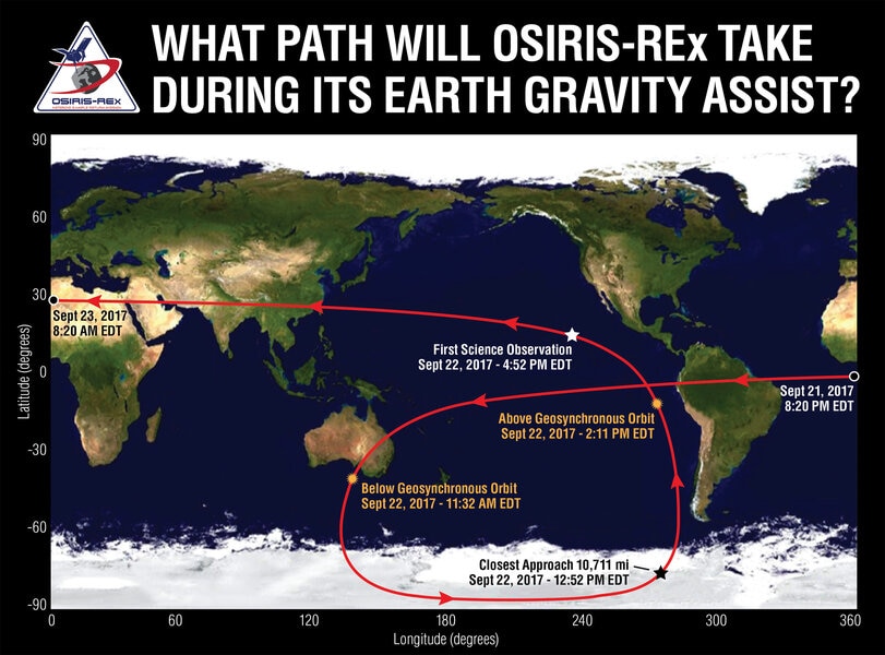
On Friday, September 22, 2017 (a day before the world didn’t end, as you may recall), the spacecraft OSIRIS-REx zipped just 11,000 km above the surface of the Earth. The purpose of the flyby was to literally steal a teeny tiny bit of Earth’s orbital energy. In return, the spacecraft got two benefits: Its trajectory was tilted by about 6°, and it sped up a bit. These are both good things! The first means it can now match orbits with the small asteroid Bennu, its target, and the second means it’ll get there faster, which is nice.
But it was also a chance to test out some of the instruments on board. And oh yeah, did they get tested. Check this out:
You may recognize that planet. This shot was taken when OSIRIS-REx was about 170,000 kilometers from the Earth, a few hours after closest approach. It swooped low over Antarctica and then back up over the Pacific Ocean, which dominates this image. In fact, nearly this whole shot is water! The Pacific Ocean is enormous.
Still, you can see reddish Australia to the lower left, the southwest United States on the upper right, and the extreme westernmost part of South America to the lower right. The cloud patterns are lovely, aren’t they?
You can also see a faint fuzzy glow just below center, like a spotlight on the ocean. In a way, that’s what it is: It’s sunlight reflected off the water. It looks like a spotlight because of geometry; only water at a certain angle to the Sun and the spacecraft will reflect light into the camera. So why is it a circle?
Because the Earth is round! Seriously. You might think of the ocean surface as flat, but of course it follows the curvature of the Earth. It’s locally flat, but on a bigger scale it’s curved. The center of the circle is where the reflection geometry is best, but the angle of the surface of the water changes as you look farther away from the center.
Think of it this way: When you look down on the Earth from space, near its center you’re looking straight down at (perpendicular to) the surface … but when you look at the edge of the face of the Earth, you’re looking at the surface of the planet along an angle essentially parallel to the surface. The angle of the surface changes because the Earth is round.
So the surface angle changes as you move away from the center of the glow in any direction, causing it to be a fading circle. Tadaa!
Something else, too: Note the phase of the Earth. It’s almost full. That means that OSIRIS-REx was flying away from Earth more or less over the centerline of the dayside of Earth. I checked, and this image was probably taken sometime after 21:00 UTC, which is very close to noon over the middle of the Pacific Ocean. So that checks out! Pretty nifty.

OSIRIS-REx — which stands for Origins, Spectral Interpretation, Resource Identification, Security, Regolith Explorer (surely one of the most tortured acronyms NASA has ever come up with) — is tasked with orbiting the 500-meter-wide asteroid Bennu, mapping it and measuring its mineral content. It will also grab a small sample of the surface material and send it back to Earth for study! It launched in September 2016 and will reach Bennu in August 2018. In March 2021 OSIRIS-REx will leave Bennu and set course back to Earth. It’ll reach here in September 2023, and eject the sample return capsule so that it lands in the Utah desert. The spacecraft itself will perform an engine burn to place it into a safe orbit around the Sun.
One more thing: That image of the Earth was taken using MapCam, one of several cameras on board OSIRIS-REx. It used three of its filters (which more or less mimic the red, green, and blue sensitivities of the human eye) to create the image. MapCam is designed to look at the dark surface of Bennu, and not so much the far brighter surface of the Earth. The image exposure time was only 0.003 seconds, which causes some issues in the camera hardware; the dark streaks at the top are because of that.
Oh, one more one more thing. From a distance of 170,000 kilometers, the Earth is about 4.2° in size (for comparison, the full Moon is about 0.5° wide in the sky). I checked; the field of view of MapCam is just about 4°! That’s why the edge of the Earth is cut off on the right side of the image.
Our planet was too big to see all at once.
I know the feeling, OSIRIS-REx. But happily, your next target is far smaller, and a much better fit for your eyes. When you get there, send us a postcard.


