Create a free profile to get unlimited access to exclusive videos, sweepstakes, and more!
Siberian Illusion

About 250 million years ago, Siberia erupted.
I mean that literally; it's thought that an upwelling plume of magma in the Earth's mantle broke through there, flooding the surface with lava. This was no minor volcanic event: The eruption lasted for a million years — yes, a million — and when it finally subsided at least a million cubic kilometers of new rock covered a vast region of northern central Russia.
This region is called the Siberian Traps*. The geology behind it is as fascinating as it is terrifying, but oddly the science of all that is not why I'm writing this. One reason is to show you an astonishing picture of part of the Siberian Traps taken by the European Space Agency's Sentinel-2A, an Earth-observing satellite, on October 28, 2016:
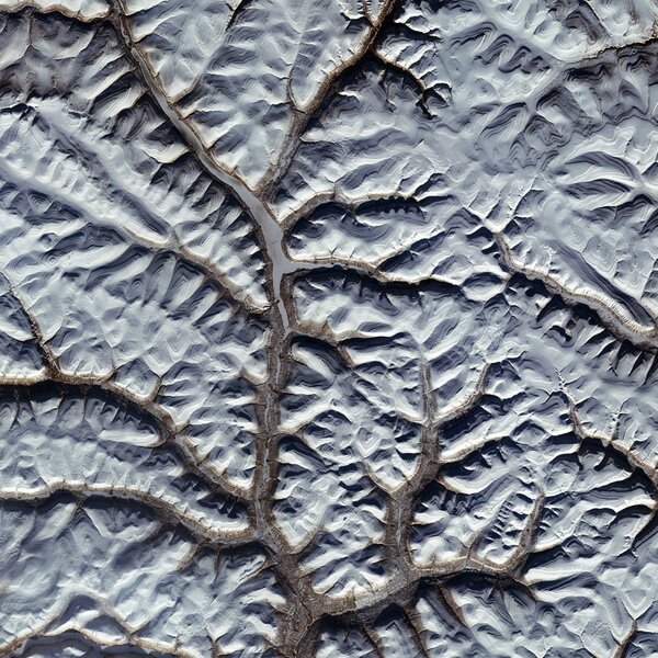
Isn't that awesome? It being October, and this being Siberia, it's no surprise to see a lot of snow there. The center of this image is just inside the Arctic Circle, and the field of view is a little over 100 kilometers, so you're seeing a lot of real estate here. This area is the Putorana Plateau, a region rich with lakes and Arctic life.
In fact, in the main brown "vein" running through the image, you can see the flat surface of a long, thin, frozen lake.
Yes, I know: That's not a flat-topped 100-km-long narrow plateau, that's a lake bed! It looks very much like it's elevated above the rest of the ground there, doesn't it? And the areas covered in snow look like hills sloping down from the brown raised area.
But that is, quite literally, an illusion. I can prove it. Watch what happens when you flip the image upside-down…
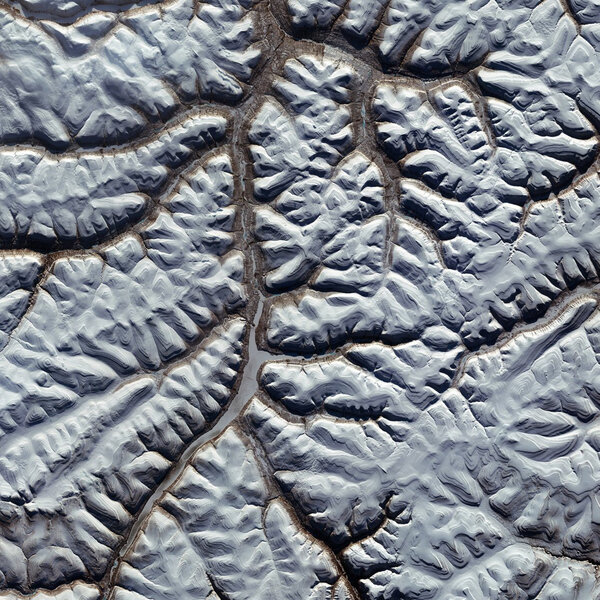
How cool is that? See it now? The brown areas really are lake beds, and the white areas are not depressions, but stepped hills sloping down toward the lake.
This photo is a fantastic example of this illusion (which, oddly, I couldn't find a proper name for; it's called the Crater Illusion on Wikipedia [note their first reference] or the Bump and Dimple Illusion elsewhere). Our brains have evolved to see light coming from the sky, from the Sun. When we look at a photograph, we automatically adjust our perspective to see it as if the light source is coming from above the photo, out of the top of the frame.
However, in the original Sentinel-2A photo, the light is actually coming from below. That makes sense; north is up in the image, and given the time of year and high latitude the Sun must be shining from the south. However, our brains don't want to see it that way, and interpret the shadows and relief as if the Sun were shining down from the top, and that inverts our sense of up and down.
Imagine a row of a hills sitting in a plain, seen from above so you're looking straight down on them. If the sunlight is coming from the top of the photo, the part of a hill facing that way (facing the top of the photo) is lit, and the other side (toward the bottom of the photo) is in shadow. A row of depressions is the opposite: The part of a pit toward the bottom of the photo is lit, and the top part in shadow. The left side of this illustration demonstrates that:

You see a row of hills, then a row of pits, then hills at the bottom, right? That's because your brain sees the light as coming from the top of the drawing.
If the sunlight is coming from the bottom, the situation is reversed. The parts of a hill and crater that were in shadow are now lit, and vice versa. Lacking other clues, the brain will see a depression as a hill if the light's coming from the bottom, and a hill as a pit. That's demonstrated by the right-hand side of the illustration above… where I simply flipped the left side vertically! It's literally the same image flipped upside down.
Our brains are ridiculous.
This illusion pops up (hahahaha! I kill me!) a lot in observations of Earth from space because it's common to get the sunlight coming up from the bottom of an image, but this is one of the strongest examples I've seen. And it's a great lesson I've had to repeat again and again over the years: When you look at photos, what you see is not what you get. It's a good thing to keep in mind when someone is absolutely positive they've taken a photo of a UFO, or Nibiru, or a face in the clouds. Our brains are powerful filters, and sometimes they really really don't want to see what's right in front of them.
*185 million years later, an eruption similar in scale formed the Deccan Traps in India, and looks to have played a large role in wiping out the non-avian dinosaurs and a lot of other life on Earth after the asteroid impacted in the Yucatan, literally half a world away.


