Create a free profile to get unlimited access to exclusive videos, sweepstakes, and more!
What created this enormous spiral in the Martian north pole? Wind. And Time.

In some ways, the north pole of Mars is like Earth's. Brutally cold, covered in water ice, yet chillingly beautiful. A big difference is that Earth's arctic area is ocean, while that of Mars is built up on solid ground.
Another big difference is that the Martian north polar cap has an enormous spiral-shaped trough system in it, covering an area of a million square kilometers — 50% bigger than Texas.
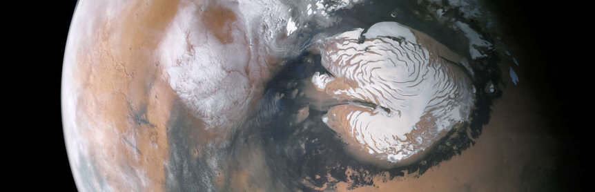
It's absolutely spectacular, one of the largest geologic megastructures in the solar system. The question is, how did this trough system form?
A team planetary scientists using data from NASA's Mars Reconnaissance Orbiter to carefully map the troughs has a hypothesis: Wind erosion.
This is very cool and how it works is a bit subtle.
They found that the troughs are not continuous, like the spiral arms of a hurricane. Instead, each arm is actually a series of small rectangular troughs laid out end-to-end, like sausage links, which they call cells. High-resolution images of the cells shows not just a lack of ice but also layering in the walls, indicative of erosion.
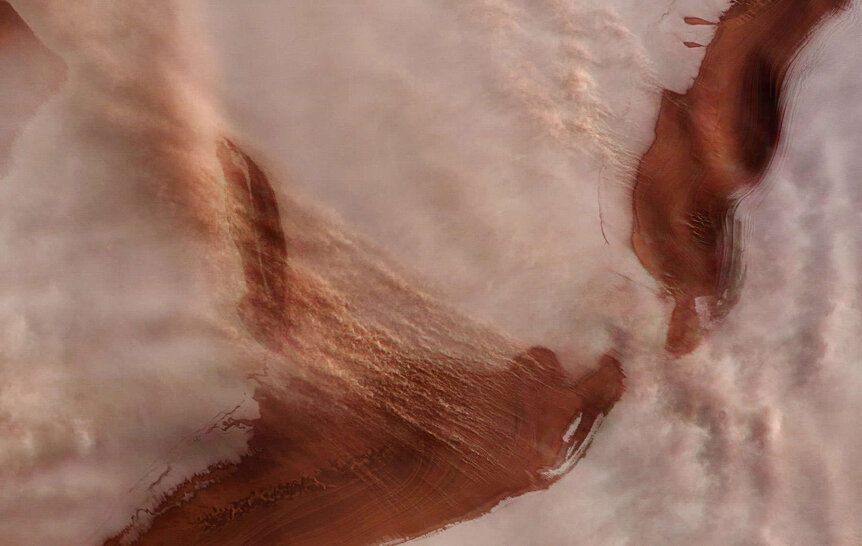
The layers are from the rock underneath the ice, part of a huge plain over the north pole called Planum Boreum (literally “northern plain”). The rock is covered in a thick sheet of permanently frozen water ice on average a couple of kilometers thick. In the winter carbon dioxide freezes out of the air on Mars and forms a dry ice deposit a meter or so thick on top. This hides the troughs in images, but ones taken in northern summer show them clearly.
Katabatic winds blow through the ice cap: Cold, denser air at higher elevations that flows down to lower elevations. The cap is higher in the center than at the edges farther south, so the wind flows south.
Except it doesn't. It would, but Mars spins. It rotates once every 24.5 hours or so, and this creates a Coriolis force which causes the wind to veer west. I explained this in an article about how this creates a hurricane's spin on Earth — read that for details.
Think of it this way: If you stood on the north pole you'd simply spin in place once per day. But if you go farther south you go in a circle around the pole, and the circle gets bigger the farther south you go. Wind flowing down from the north moves south, but the land under it moves faster to the east, leaving it behind. If you were standing on that land, you'd feel a wind blowing to the southwest. The end result is that a stream of air will bend to the west, farther west the farther south you go.
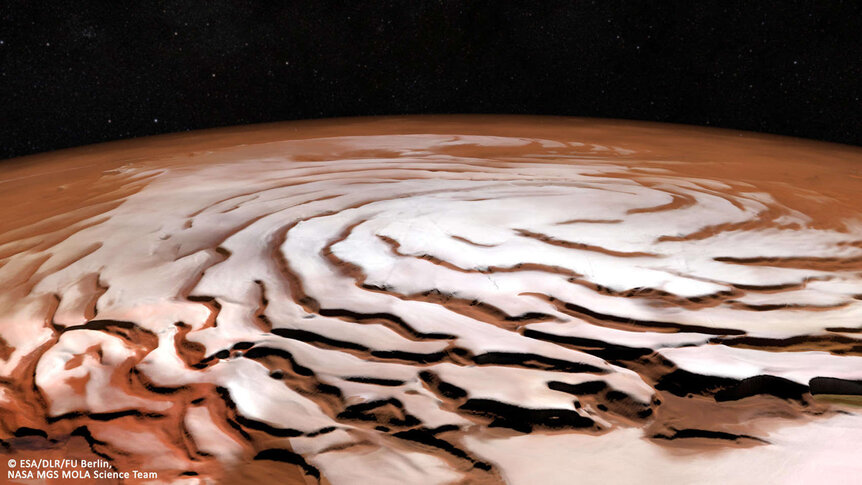
The scientists hypothesize that if that wind hits a small pit in the ice it will erode it, making it bigger and deeper. When it hits the downwind wall of the pit the air will naturally be pushed to the sides. Over time this elongates the pit, creating a roughly rectangular depression or trough in the ice perpendicular to the wind direction. The wind always seems to flow to the southwest due to the Coriolis force, so these small troughs will naturally align themselves in a clockwise spiral going around the pole.
There are some complicated details to this, but that's the overall picture. There is an older idea that katabatic winds flow down the spiral arms, but this new idea has it flowing across them, and that's why they form in the first place.
They measured the amount of ice eroded away, and it's staggering: 40,000 cubic kilometers! That's ten times the volume of the Grand Canyon. It's a lot of ice. Where did it go?
They think it wound up in the mid-latitude regions of Mars to the south. A layer of water ice exists under the dust and sand dunes there, discovered when small, young impact craters were seen from orbit: The impacting asteroids carved out chunks of the surface, revealing fresh water ice just below the surface.
When did this spiral pattern form? It's not clear, but looking at crater counts, climate variations on Mars, and the erosion in the ice versus known depositional ages, they find the troughs may have formed as long as a few million years ago, but might also be incredibly young: Just 50,000 or so years old.
So, not only do they form one of the largest megastructures in the solar system, it's also one of the youngest. How young, though, isn't clear.
Mind you this is a hypothesis, and not proven, but it does seem — if you will — to hold water. Frozen water, but still. It'll be interesting to see if other planetary scientists can in time support or refute it.
And this is another way Mars is like Earth: It's still changing, all the time.


