Create a free profile to get unlimited access to exclusive videos, sweepstakes, and more!
Astrophysicists have created the most accurate 2D 'Flat Map' of the Earth ever made

Correcting distortions and distances seen in previous all-encompassing maps of our Big Blue Marble like the Mercatur Projection, Winkel Tripel Projection, and Richard Buckminster Fuller's polyhedral maps, astrophysicists have now composed the most accurate flat map of the Earth.
This seemingly simple task has annoyed and challenged cartographers for centuries, and while there will never be a perfect way to portray Earth's sphere on a plain two-dimensional map, this latest attempt is by far the best.
In a new study published last week for the arXiv database, a Princeton University team presented their efforts consisting of a pair of pancake maps that can be observed side-by-side or back-to-back. There's an absence of boundary cuts, and if you require distance measurements spanning one hemisphere to the other, it's an easy job employing a string or a measuring tape to reach from one pancake to the other.
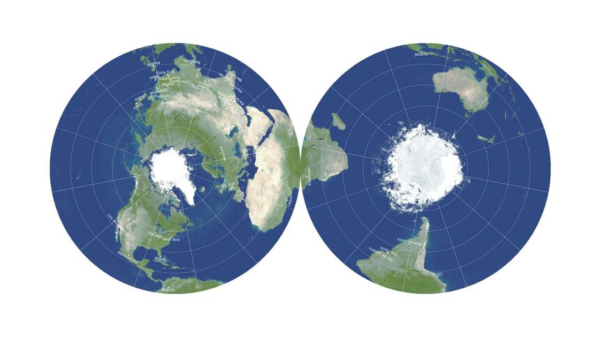
"This is a map you can hold in your hand," explained lead researcher J. Richard Gott, an emeritus professor of astrophysics at Princeton University. "The map can be printed front-and-back on a single magazine page, ready for the reader to cut out."
The new pancake map borrows data found from research on multi-sided 3D shapes called polyhedra. American architect Richard Buckminster Fuller created a polyhedral map in 1943 using outlines of geometric shapes that comprised a world map and could be folded to make a whole polyhedral globe, but it couldn't overcome distance errors for certain oceans and continents.
""Our map is actually more like the globe than other flat maps," Gott added. "To see all of the globe, you have to rotate it; to see all of our new map, you simply have to flip it over. If you're an ant, you can crawl from one side ... to the other. We have continuity over the equator. [Africa] and South America are draped over the edge, like a sheet over a clothesline, but they're continuous."
The circular map also has far less distance errors than any other 2D flat map and doesn't downsize or supersize the area of certain oceans or landmasses.
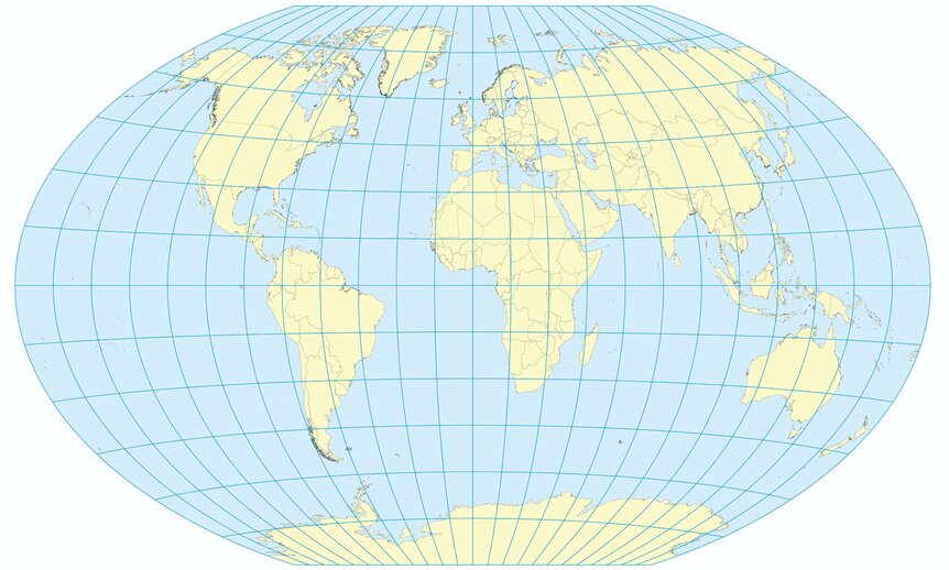
In designing their detailed representation of the Earth, the team gave top-ratings to the Winkel Tripel flat map projection proposed by German cartographer Oswald Winkel in 1921 and commonly used by the National Geographic Society. However, this map does suffer from the boundary splitting issue with the Pacific Ocean cut in two, delivering the incorrect impression that Asia and Hawaii are separated more than they actually are.
"One can't make everything perfect on a flat Earth map," Gott noted, enphasizing that his team hoped to construct a map with the least possible mistakes. "A map that is good at one thing may not be good at depicting other things We're proposing a radically different kind of map, and we beat Winkel Tripel on each and every one of the six errors."


